GPS is a satellite navigation system that allows you to determine the location of an object in the earth’s coordinate system. GPS can most accurately determine the coordinates of an object on planet Earth in almost any weather (except for the polar regions). This is a development of the US Department of Defense, but has recently been used by civilians around the world. To use satellite navigation, you need a special receiver, which is installed in almost all smartphones produced in the last decade. How to turn on GPS on your Android smartphone in order to take advantage of its capabilities can be learned from this manual.
How to enable GPS on Android
Devices running the Android operating system are equipped with GPS receivers to determine location. Many programs and systems are built around satellite navigation, and a smartphone can interact with them.
For example, services: Yandex.Maps, Google Maps, 2GIS and others use GPS to determine the coordinates of a smartphone and, through their own algorithms, indicate the location on the map in real time.
Brief instructions on how to enable location services
For the function to work, it must be activated:
- Open one of the applications that works with GPS (for example, Google Maps).
- Next to the map, click on the positioning icon and agree to enable “Geolocation”.
- After activation, click on the icon again to move you on the map to the location that identified you.
What geolocation settings are on the device?
Important! If you disable geolocation, apps and services will not have access to information about your phone's location. In this case, search results and advertising will be selected based on the IP address.
Google has several services that use user location data, including:
- Android location detection (or Google geolocation) Allows you to more accurately determine your phone's location. Find out how to enable this feature.
- Google Account Location History Allows you to check and edit a list of places you've been with your phone. Find out how to enable this feature.
- Google Maps Location Sharing Allows you to show other users where your phone is. Find out how to enable this feature.
- Location information in Search This information can help you get more useful results when you search for something on Google. Learn more about how to control which sites and apps can access your location data.
GPS Basics
After the launch of the first earth satellite in the fifties, American scientists noticed a certain phenomenon: the frequency of the reception signal increases as the satellite approaches and decreases as it moves away.
That is, if you know the exact coordinates of your location on planet Earth, you can calculate the position and speed of an artificial satellite. Or, conversely, knowing the exact location of the satellite in orbit, you can determine the exact coordinates of the receiver, even while moving.
The GPS system works according to this principle:
- The satellite broadcasts a signal from outer space.
- Each GPS receiver, through this signal, calculates its position in three coordinates in real time.
The following equipment is involved:
- From space – satellites located in medium-Earth orbit.
- Main control – main station + additional stations + antennas.
- Custom – GPS receivers that are registered with the state. institutes and almost a billion receivers built into navigators and smartphones.
Since GPS is a purely American development, other countries did not stand aside and launched their own navigation systems:
- Russia – GLONASS.
- EU countries – Galileo.
- China – Beidou.
- Japan - QZSS.
- India - IRNSS.
Android smartphones can work with multiple navigation systems, so there will be no problems with location determination.
But a modern location service uses more than just navigation systems. The list includes:
- Geodata of Wi-Fi access points.
- Hotspot geodata
- Cell towers.
- Google services, which, through a complex of systems and smartphone sensors, determine the location of the device “more accurately.”
The use of this equipment is necessary to increase the accuracy of coordinate calculations. But work through these communication modules is regulated by Android smartphones.
At the same time, Google services are the only software package that uses, if necessary, even a turned off GPS. Some manufacturers (e.g. Samsung, Xiaomi) use their own tools for hidden location detection, similar to Google. So keep that in mind.
What to do if GPS doesn't work
Let's consider all possible reasons for GPS failure:
- The GPS module is broken . All that remains is to take the phone for repair. If the theory is confirmed, it will not be possible to solve the problem programmatically.
- The phone's memory is full and is not enough to activate communication with satellites. In this case, you need to clear the memory and restart the phone.
- Presence of malware . In this case, you should check your mobile device with an antivirus and reboot it.
- Incorrect firmware . This is a possible reason if you have modified your phone with unofficial firmware. Try performing a hard reset.
- Weak satellite signal. Although most of the Earth is covered by a network of GPS satellites, sometimes, especially far from civilization, the GPS signal is extremely weak. In this case, you need to move to another place.
Battery status when using GPS
Using the geolocation function, the battery loses charge faster than usual. Fortunately, Android 9 version allows you to find out the amount of charge used by an application that used GPS. Unfortunately, the calculations are approximate. Access to Wi-Fi and GSM modules is also taken into account:
Step 1. Swipe down from the middle of the screen to bring up the search bar.
Step 2. Enter the phrase “GPS” and go to the appropriate section.
Step 3. Activate the function by moving the slider to the “active” state.
Step 4: Go to the app that says “High battery drain.”
Step 5: Select Energy Details. Scroll down to GPS Hours and Power Consumption.
Step 6: If an app is consuming your battery excessively, you can go back to the About app window, select Permissions, and turn off Location Data.
When customization is necessary: a Mediatek curiosity
Today, Mediatek (also known as MTK) is one of the leaders in the production of mobile processors. Even such giants as Sony, LG or HTC today create smartphones using MTK processors. But there was a time when the processors of this Taiwanese company were used only in poor iPhone clones or dual-SIM dialers.
In 2012-2014, Mediatek released quite decent chipsets, but they constantly had a problem: GPS did not work correctly. Satellites with such devices behave according to the quote: “I am difficult to find, easy to lose...”
It was all about the settings of the EPO auxiliary service. This service, developed by Mediatek, helps calculate the orbits of navigation satellites in advance. But here’s the problem: the default EPO data in Chinese phones is designed for Asia and fails when used in Europe!
This can be easily fixed in modern models. Let us remind you that all these instructions are only suitable for smartphones with MTK processors:
- Download and install the MTK Engineering Mode Start application, which allows you to enter the engineering menu of your smartphone (https://play.google.com/store/apps/details?id=com.themonsterit.EngineerStarter&hl=ru).
Yes, this is far from the easiest procedure. Depending on the version of the MTK processor (we described the steps for the MT6592 platform), the procedure may differ slightly, but essentially remains the same. But after these steps, GPS on your smartphone will work great.
Sources used:
- https://phone-insider.com/android-gps.html
- https://softdroid.net/vklyuchit-otklyuchit-nastroit-gps-android
- https://mrandroid.ru/kak-otkljuchit-otslezhivanie-mestopolozhenija-na-android/
- https://mobidrom.ru/kak-nastroit-gps-na-android-devajse-ili-vovse-otklyuchit-ego/
- https://andevice.ru/nastrojka-gps-na-android/
SHARE Facebook
- tweet
Previous articleHow to receive calls without touching your smartphone (Android)
Next articleHow to turn off offline mode in Internet Explorer
Universal methods for turning on GPS
You can activate the terrain positioning function on your smartphone in several ways.
Method #1: Using the Quick Access Toolbar
The most convenient and simplest method is to open through the quick access panel:
Step 1. Swipe down from top to bottom to open the curtain with functions. If necessary, lower the panel lower.
Step 2. One of the buttons with a marker thumbnail will be the desired function. It can be called differently: GPS, location, geolocation, geolocation, etc.
If it is not on the panel, click on the “pencil” icon and go to icon settings.
Next, drag the function you need onto the panel, and hide the unnecessary ones from the Quick Launch panel.
Method number 2. Using the Settings app
A long tap on the icon from the taskbar goes to the section specified in this method. You can also go like this:
- Open Settings.
- Go to the "Security" section.
- Open Location Data.
- A slider will be available at the very top. Set it to "active" to enable geographic positioning.
Why do you need GPS in a smartphone and how is it used?
The location system is used in Android not only for navigation, but also in a number of other cases.
For example, many Google applications actively and constantly determine the location of the smartphone and its user. The obtained data is used for a variety of purposes.
Thus, Google Search helps you find nearby cafes, restaurants and other establishments. Just type “Where you can eat” into the search bar, and the smart system will display a list of nearby public catering establishments. Shops, train stations, hospitals, public institutions and other organizations - nothing can hide from the omnipresent “eye” of Google, and the search giant will help you find those that are closest to the searcher.
GPS is also used to create reminders linked to geographic coordinates. This functionality is implemented in Google Keep. There you can make a list of products and set a reminder so that the application displays a corresponding notification as soon as the smartphone - and its owner - is in the store.
Of course, in this case, GPS is a tool, and it is up to the user how it will be used.
GPS is also used in the camera - coordinates are “attached” to the photographs taken. This is excellent proof that the photograph taken from the top of Elbrus is not the result of photoshopping, and it was taken exactly there, on this mountain.
Anti-theft devices also operate based on GPS positioning. All programs that allow you to find a lost Android device require the smartphone location module to be enabled. And yes, it works!
And finally, GPS is also used in navigation, be it working with cartographic systems (Google Maps, Yandex Maps) or directly determining and plotting a route (Navitel, 2GIS).
In general, the GPS module is a useful thing. Well, except for a few “buts”.
Confidentiality
The issue of privacy has always been a concern for those who use the GPS function. Are they following him? Who? And if so, for what purposes?
To the first question, the answer is: naturally, they are watching. The GPS system itself is positioned as coordinate tracking.
Who's watching? Here it is better to go the other way and cite the large links in the chain involved in potential surveillance:
- US military personnel, as the satellite control headquarters is located at the Schriever military base.
- Cellular operator - tracking via GPS complements the already possible tracking via the GSM module.
- Smartphone manufacturer. This is indicated in the privacy policy of your gadget.
- Google services - this is specified in the privacy policy of the owner of these services and the Android operating system itself.
- Third-party applications are those that you installed manually and to which you granted access to geodata yourself.
For what purposes? Typically, purely commercial goals are pursued: displaying advertising, manipulating results in search results, improving all kinds of services after analyzing data sets, including your information.
According to corporations, the data is not personalized and is used only for analytical purposes to obtain any personal benefit.
Why do you need GPS?
Decades ago, GPS satellites were only available to the military. But the Americans quickly realized that big money could be made from navigation chips, applications and maps. As a result, ordinary people gained access to the technology - they just needed to acquire the appropriate device. Initially, these were specialized GPS navigators. And now the navigation module has seriously decreased in size, and therefore it can be built even into an ordinary smartphone.
A GPS signal helps you understand where in the world you are now. This is useful for several reasons:
- The navigation app will help you not get lost in the forest;
- With navigation you can navigate even in an unfamiliar city;
- You can easily find the address you need;
- You escape from traffic jams - the “Traffic” service helps you avoid them;
- Various apps show you nearby eateries and shopping centers;
- GPS helps determine your speed.
In short, a navigation chip can be very useful. But you will have to pay for using it. If you decide to turn on GPS on Android, then get ready for higher power consumption. This is most noticeable on older devices that do not support A-GPS technology. Also, inexpensive and older smartphones have problems with GPS signal reception. Our separate article will help you get closer to solving it.
Setting up GPS through the engineering menu
To configure the navigation application through the engineering menu, it is recommended to turn on Wi-Fi or mobile Internet. Then you need to do the following:
- Dial *#*#3646633#*#* (codes may differ for different models).
- Select the following items: Location - Location Based Service - EPO .
- Check the boxes next to Enable EPO , Auto Download .
- Go back and click on YGPS .
- Select the Information . Click Full , Cold , aGPS-restart .
- Go to the Sattelites .
- The red dots should be replaced with green ones. This may take about an hour.
- Exit YGPS , then exit the engineering menu.
- Turn off Wi-Fi. The device will find the satellites itself.
Sending location data
Also in the "Location" window, you can enable or disable the use of data about your location by Google services. To do this, go to the “Sending geodata” section.
In the “Sending Data” section there are two additional sections: “Sending Geodata” and “Location History”. Open each of these sections and turn off (or turn on) the use of your location data.
By the way, you might be wondering how GPS is turned on on an iPhone.
See also:
- How to enable geolocation on Android
- How to enable battery percentage on Android
- How to Enable USB Debugging Mode on Android
How to find out the number of nearby GPS satellites for Android
You can check the number of nearby GPS satellites for Android using special applications that must first be installed on the gadget.
The most popular application for setting up, calibrating, and managing the GPS module built into a smartphone is called GPS Essentials. Through it you can see the number of satellites to which the smartphone connects when the geolocation option is activated. To do this, you need to find the Satellites section in the application; all nearby GPS satellites will be displayed on the screen.
Another program through which you can also find out the number of GPS satellites in your phone is the GPS Test program. In it you can also find out other important parameters of the module.
Position and signal strength of satellites via the GPS-Status Data application
Another application that can determine the position of satellites, their signal strength, and also has a digital speedometer, compass and other functions is called inViu GPS-details.
Similar to the previous GPS-Status Data application, it has an English-language interface. However, thanks to it, you can also determine all the nearest satellites, their signal strength and position in the sky. The application also contains a speedometer, compass, and basic data that may be useful to the user.
To catch a GPS signal, strengthen and boost it on Android, you need to make sure that all the settings on your smartphone or tablet are correct. Sometimes it is useful to turn off the GPS module to save battery power using the icon in the “curtain”.
GPS – help or panacea for the user?
Before moving on to describing the correct settings, it is worth mentioning about this system, namely, its advantages and disadvantages. As you know, the geolocation system allows anyone to know their location, no matter where they are. However, two negative factors can be identified:
- If you use the GPS option on your Android frequently, you will see that the battery drains quite quickly.
- The GPS system constantly monitors your movements, and all the data, oddly enough, is stored under your Google account. They even have a special service with which you can view where you were at a certain time, what places you visited, what countries you visited, and much more. And who knows what else Google has left when using this module...
Bottom line
GPS connection allows you to quickly navigate the area, find your phone if lost, and much more. The working location tracking function consumes almost no battery power, while providing a number of benefits to the user. Therefore, it is very important to know how to enable and configure it.
@appsetter.ru
Blog > Android
In order to determine its operating mode, you need to follow this path:
- To avoid getting lost in the forest: rating of the best smartphones of 2021 with a good GPS receiver for navigation
After this, a menu will appear with three options:
- "By all sources" . This is the most accurate mode of operation of your device's GPS module. But it is precisely this “precision” that wastes the energy reserves of your battery. This mode uses satellites, Wi-Fi and mobile networks to determine location. If you have this mode enabled, it means that the module responsible for the operation of this function is constantly in the active position. It monitors the space and easily helps determine the location not only outdoors, but also indoors. Unlike navigators, devices that are used to plot routes, smartphones have the ability to use not only satellites, but also other sources. For example, the Internet. With its help, and with the help of certain utilities in your gadget, it can show the location even without connecting to satellites.
- "By network coordinates" . Actually, this mode is described in the previous paragraph. But, unlike the “Across all sources” mode, it uses only wireless networks (Wi-Fi, Bluetooth and mobile networks). When you select this mode, communication with satellites is disabled, which helps to significantly save battery power. At the same time, the accuracy of location determination does not suffer critically.
- "By GPS satellites" . Unlike the previous mode, this only uses GPS satellites and the device module that processes their signals. By selecting this mode and entering a room, your gadget will “lose the scent”, since the signal with satellites will be lost.
If you want to increase the life of the device from one battery charge to another, then set the “By network coordinates” mode. It's also a good idea to deactivate the location mode in your device's notification panel.
If the battery of your smartphone or tablet can handle the load, then turn on the “Across all sources” mode. Thanks to it, you can not only more accurately determine your location, but also use personalized Google search.
Configuration via the engineering menu
Unfortunately, not all devices can quickly find satellites, connect to them and maintain a stable connection. Some cheap smartphone models cannot boast of flawless operation of the GPS module. And this can affect you at the most inopportune moment. For example, when you need to figure out where to go while in an unfamiliar area.
One of the reasons for problems with the GPS sensor is its incorrect operation in the latitudes of our country. This happens especially often with Chinese cheap smartphones. But this situation can be corrected with the help of simple manipulations with such a sensor through the engineering menu. To do this, you need to have superuser rights (How to do this? Read this article ).
Turn on your Wi-Fi connection and GPS and go out into the open. A balcony can also be used for this purpose.
We type on the keyboard *#*#3646633*#*# , *#15963#* or *#*#4636#*#* . Using one of these service codes you can enter the engineering menu. (You can learn about other Android service codes from this article .)
Above are three engineering codes. One of them should suit your device. But, if none of the listed codes work, then use the Mobileuncle ToolHero . With its help, you can access the engineering menu from devices that do not support the above mentioned engineering codes.
In the program you need to select the Location . To do this, you need to scroll a little to the left. In this tab, go to the Location Based Service .
In the EPO Enable EPO and Auto Download items active. EPO is a file in your system that is responsible for the coordinates of satellites and their trajectories. Initially, it is not active on all devices.
Now you need to go to the YGPS (to do this, return to the previous level). In the Satellites section you can see the current satellite layout. If satellites are visible on the diagram, then the device also “sees” them.
Go to the Information and select full . We wait a couple of seconds and click AGPS restart .
We return again to the satellite layout diagram (Satellites tab). The dots next to the satellites should turn green. This means that the device can connect to them.
IMPORTANT: Sometimes, even with the correct GPS settings, the device may not always connect to satellites. This may be affected by interference, bad weather and other situations.
Reboot your device. After the steps described above, it should better receive the GPS , find and quickly connect to satellites.
As you can see, setting up the GPS and choosing the most optimal operating mode for the “Location” is quite simple. If you still have any questions regarding this article, be sure to write them in the comments.
Installing a GPS navigator, using Google Maps
How to enable Okay Google on Android - activating the assistant
Those people who are used to traveling a lot and often need to learn how to install a GPS navigator on Android. It will become an indispensable utility, useful on the go. Almost every Android device has a default navigator. But if you wish, you can download any other similar one from the Play Market for free online.
Smartphones have maps from Google, they are called Google Maps. They allow you to receive for free the necessary data and information about any coordinates, traffic congestion, create routes and much more. For correct operation, you need to periodically update the preinstalled application.
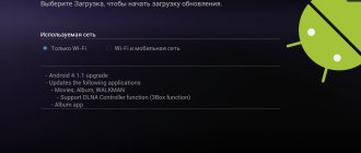
Google Maps update
After this you can:
- launch the navigator;
- to plot a route, press the blue “Go” button;
- select the starting and ending points of departure and destination;
- you can also choose any type of transport;
- the system will calculate the time spent on the road and offer the best route option.
As an alternative, for example, you can use Yandex.Navigator. To do this you need:
- go to Play Market;
- write in the Yandex Navigator search;
- click on the “Install” button next to its name;
- wait for the download to begin and complete;
- then open the application, accept the terms of the license agreement, give access to the microphone and device location data;
After this, the user will have access to a map of the city of the area where he is located.
Enabling the microphone greatly simplifies the process of using and managing cards. Voice commands are available. To build any route, just say “Hello, Alice” and specify the address.