Geolocation is one of the main functions on a modern smartphone. Enabling this tool helps you get the information you need based on your device location. For example, you can use your phone as a navigator, find the nearest shops and restaurants, find out about traffic jams, indicate the location in photographs, transmit information to other users or emergency services, and find a mobile device if lost. You can activate the function for the entire system at once or separately for each application. You can learn how to enable geolocation on Android from this article.
What is geolocation on Android
Geolocation is a function of determining the real location of a phone on a map. That is, the person is somewhere in the same place with the phone, and it displays the real location, showing exact coordinates and data.
Geolocation is a very important tool not only for applications that require location data, but also for protecting user privacy and control.
Access to geolocations can be requested not only by those applications that require precise coordinate information, but also by those applications that track the user’s location and where he logs into his account. This is done only to protect personal information and data.
How does geolocation work on a phone?
The geolocation system is a large complex of processes aimed at determining the user’s location. There are two ways to determine:
- Through mobile operators;
- Via satellite
Connecting geolocation through mobile operators requires an Internet connection and the presence of a mandatory cellular connection.
Satellite operation is not available through all mobile phones. As a rule, this method is much more accurate, since only the approximate location of the object can be determined through mobile operators.
If the phone does have a special built-in module, then the accuracy of displaying the location of the object is very high. The satellite operation algorithm is as follows:
- A special module is activated on the phone, which records the location of an object at a certain time;
- Satellites direct their beams to the receiver. A telephone is used as a receiver;
- After which the data from the phone is compared with time and the satellite, the approximate location is calculated.
Such a system allows you to accurately determine coordinates and also does not require an Internet connection, unlike cellular operators.
Programs for building routes to Android addresses
All applications that can work with maps can be roughly divided into two types: offline and online access. The latter require a connection to servers to work, which contain map data, updates, and can download missing files. Connection is required when building a route. If you save it later in the device’s memory (cache), you will not need to re-activate the Internet. There are a number of programs that always require access to the network. The disadvantages of such cards are the following factors:
- Uploading maps requires traffic, the costs are low, but they exist;
- The battery life of a mobile phone without recharging is reduced due to a constantly active connection to the network;
- Not everywhere there is access to the Internet.
Offline programs do not require an Internet connection: you only need to connect to a computer that has access to the network. Through the cord you can transfer cards from it to your mobile or other Android devices. The route is built based on those already existing in the database, so the user will not be able to create completely new routes. In addition, you will have to store a large amount of data on your phone.
Yandex.Navigator
This is a service from the Yandex search engine that can work both online and offline. The navigator helps solve problems and unforeseen situations that arise on the road. First you need to install it on a mobile device with the Android operating system:
- Open the official Google store.
- Through the search, find Yandex.Navigator.
- Click on the “Install” icon.
To start using it, you need to perform the initial setup of the application. The owner of the mobile phone can set the parameters for himself according to the following instructions:
- Click on the application icon that appears on your smartphone screen.
- Only at the first launch, two requests from the program will pop up. Confirm access to geolocation and microphone.
- It is recommended to perform both permissions so that the navigator works as correctly as possible.
After the initial settings, a map will appear with an arrow in the center indicating your current location. Next, you can set the following additional settings:
- Click on the “Menu” button located at the bottom right. Open the "Settings" section.
- The “Map View” item is responsible for switching between satellite and standard road and street maps. You can choose one of the options, but the schematic option is considered more convenient.
- To switch to offline mode, you need to open the “Download maps” item, then click on the search line. A selection of countries, territories, regions, cities and provinces will appear. Find the area you need.
- The "Cursor" tab is responsible for the icon of your current position.
The “Sound” settings section is responsible for selecting the language in which the program will comment on the route and road information. On this tab you can make the following settings:
- Launch the Narrator tab.
- Select the setting that suits you (female or male voice, etc.).
- Leave the last three items enabled so that you can get directions using the voice command “Listen, Yandex.” Just dictate your destination and the program will show you the way.
These are all the basic settings before starting to work with the program. To build a route, you can use two input methods:
- Manual. Click on the search line, enter the required address and tap on “Search”. The navigator will suggest street options.
- Voice. Say the phrase “Listen, Yandex.” A window will appear at the bottom with the word “Speak” - name the street or destination. This is very convenient so as not to be distracted from driving.
Yandex.Navigator will offer two shortest routes and the distance to the destination. Select the appropriate one and click the “Let’s go” button. The Android device will go into travel mode, the remaining travel time, speed, and distance to the first turn will be indicated. Follow the geolocation data and the speaker's instructions. When connected online, the utility indicates traffic congestion, possible and existing traffic jams. You can activate this function by clicking on the traffic light on the top right.
To work with offline mode, you do not need the Internet; an Android mobile phone and enabled geolocation via GPS will suffice. To plot a route, you need to download the terrain files to your mobile phone in advance. The algorithm for constructing a path in the presence of maps coincides with the online mode. To remember the route in advance, you need to click on the “My Places” button and save.
- New economic rescue plan after the pandemic
- How to force the developer to eliminate defects
- Why do cucumber ovaries turn yellow in a greenhouse or open ground - the main reasons
2GIS
2GIS is an independent project that does not belong to any of the search engines. Geolocation on Android is implemented on the principle of a navigator; you can set a route from point A to point B by indicating the address, the name of the organization, or simply pointing your finger anywhere on the map. The main disadvantage of the Android application is that it is paid. To use it on a PC, you do not need to buy it.
The program will calculate the optimal route and show you how to get there by public transport. The utility does not support walking or driving, so it is not suitable for motorists. 2GIS still has little content; not all cities in Russia exist, not to mention foreign ones, but the developers are constantly updating maps. The program is used more as a reference book than as an option for geolocation on Android.
How to enable geolocation on your phone
Geolocation is available on almost all Android phones. There are several connection methods that will help the user to easily connect and determine their coordinates. This will help him not only find the route, but also calculate many interesting measurements. Electronic bracelets, by the way, also have the ability to connect geolocation.
To connect the GPS function to Android, you need:
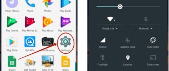
- Go to phone settings. Most often they are located on the main screen and look like a gear;
- Going to the settings, we find the “Personal” section, and in it the “Connection” item;
- Then, using the slider shift, activate the function opposite the word “Geodata”.
The function of determining the user's location is now available on Android. In the mode line, you can select several operators who will receive and with the help of which coordinates will be determined.
Location services operating modes
Choosing a service mode is a very important step. Not only the accuracy of the determination, but also other factors depends on it. For example, when connecting as a mobile network operator, the user runs the risk of wasting the battery for nothing. If he chooses GPS as the service operating mode, he guarantees himself not only accuracy of determination, but also battery saving.
There are several types of service operating modes:
- According to all sources. That is, the user can choose both determination using mobile operators and GPS immediately. Such a function is often called “High Accuracy” in systems, since coordinates from one base are superimposed on coordinates from another and, as a result, a more accurate percentage and geodata allocation data are calculated;
- Using mobile operators. Operators such as MTS, Beeline or Tele2 provide their definition services, so the user only needs a mobile network connection and unlimited Internet. This method does not give such accurate results as the first or third, but is also a good alternative;
- The final mode is based on GPS satellites. One of the most accurate methods, apart from the first. The satellites were adapted to accurately determine the location of a particular object, so all phones are equipped with a special module that allows you to easily and quickly determine geodata.
Selecting a service mode for determining geodata is quite simple if the user knows his capabilities and goals. If he needs fast and ultra-precise determination, then he should turn his attention to the first mode. If money does not play a role for him, then he can choose mobile operators.
Location history and geodata transfer
If the user exits the “Locations” settings and scrolls down a little, he will find a huge number of interesting and unusual functions that can also be configured and viewed. The first of these is the history of the location.
This function records all points and coordinates, that is, the places where the user was. You can view your location history at any time, and also turn it off when you need it.
The history is saved in the servers of the installed system on Android - on Google. To disable this feature, simply move the slider and then the device will not save user data.
The user can access the history at any time, since it is all recorded in the history. To do this, just go to Google Maps, namely to the “Chronicle” section. All user actions are displayed there.
The second no less interesting function is the transfer of geodata. It is needed so that the user can transfer his location to another network user, if there is such a need. Situations are different, so the transfer of geodata is a very important function, especially in lethal situations when:
- A car was stolen, the mobile phone was left in the car;
- When the user simply does not know his location;
- When your phone is lost.
Determining the location of the phone via Google
If you have a profile on the Google service, you can link your device to it. The search giant offers a special “Find Device” feature, which is activated the first time you log into your account from a mobile phone. You will have the opportunity to play a loud sound even when the sound is turned off, lock the device, or completely erase all data from it. One of the “Show on map” sections determines the location of the mobile phone, but only under the condition that:
- the device is turned on and associated with this Google account;
- there is a connection to the Internet;
- geolocation function activated;
- The Find My Device feature is activated.
To view the location of your Android device inside your Google account, you need to do the following:
- Go to your account page.
- At the top there will be a selection of devices (if you use several), select the one you need.
- A list of actions will appear: send a sound signal, block, find the device.
- If the above conditions are met, then the point where the mobile is located will appear on the map.
- If some parameters are disabled, it will show the last place where the phone was fixed.
Find My Android
This geolocation program for Android is suitable for all models from version 1.6. You need to download the application and transfer it to your phone via cable. Next, unpack the installation file; after installation, the application works in offline mode and does not manifest itself in any way. Third-party data storage services are not used; all data is sent to your email on your behalf.
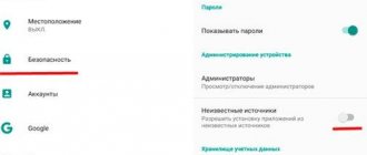
When you download and install wiretapping and tracking utilities, you automatically confirm that the program will not be used unlawfully. To use the program you must complete additional steps:
- Before installation, you must activate the “Unknown sources” item in the Android device settings so that you can install the utility.
- From the phone you want to track, go to the website and click on the “Install” button.
- The program will require the right to access the Internet, send and read SMS. Confirm all these tolerances.
- To receive location data, send an SMS to your mobile phone with the =location= command. You will receive a response SMS with coordinates.
Google Maps
Another application from Google, which specializes in geolocation. Using maps, you can plot the best route around the world. The app's useful "Show where I am" feature helps track the user's location. The application works on both Android and iOS devices. The program must be installed on both phones (yours and the one whose owner you want to track). You need to do the following:
- On the device you are tracking, activate the “Show where I am” feature from your Google account.
- Select a tracking period, enter your phone number or email.
- Next, on your mobile, go to Google Maps, open the “Show where I am” section and select the tracked phone from the list.
How to set up geolocation on your phone
In fact, the user can configure geolocation very limitedly, that is, on an Android device there are few variations offered on how to use geolocation and how to change it.
The only actions that the user can perform are:
- Set mode;
- Set up display and transmission;
- Set up the display of chronicles;
- Enable energy saving.
In the first point, a person can choose the mode that is convenient for him. The modes have been described previously, so there is no point in repeating their duties and operation again.
Displaying and transmitting data is an action when the user can select a limited circle of people to whom his location data will be available. The user may also not allow any of his people to know his coordinate location.
This feature may be very useful for parents who want to know where their child is.
Setting up the display of chronicles is to disable or enable. A person can configure the history to be saved in the device’s memory, and also so that it is not accessible and is a “pass-through” option for applications.
The energy saving feature will be needed by those who use geodata through mobile operators, as they take too much interest from the phone’s battery. To configure, you also need to go to “Location” in the settings, and then scroll down, find this time and switch the slider to the active state.
In fact, these are all the settings that the owner of a phone on an Android system can make.
Applications for tracking a person
You can use GPS not only to plot a route and make it easier to travel to unfamiliar places. If desired, a person can determine the location of the Android phone. The reasons for this are very different: loss of a mobile phone, mistrust of a loved one or employee, worries about a child. Tracking utilities connect to the geolocation system and transmit location data to you. Below are popular options for Android.
GPS tracker Family Locator
The name indicates that the application helps keep track of relatives and children, but only with their knowledge. For geographic positioning, you must enable a GPS tracker, which will send data to your computer or mobile phone. The application is installed on several Android mobile phones, then a “Circle” is created. Everyone must confirm permission to be tracked using geolocation.
The main disadvantage of the program is that the GPS tracker must be activated, without it it will not be possible to establish the location. You can download the Family Locator GPS tracker for free, download the file to your phone via a USB cable and run the installation. The application has the following options:
- sending an SOS signal with one click;
- determines location when GPS is turned on;
- sends a message when deviating from the direction specified by the route;
- you can set the arrival point, the application will send a message when the user reaches it.
Lost Android
You can download the utility directly from the official Android application store, it is distributed free of charge. Helps you find out, using geolocation, where the mobile phone on which the program is installed is located. To manage and view data, you must register on the developer’s website and you will be given access to your personal account. The main drawback is the lack of Russian language; the interface is entirely in English. The application has high potential for remote control of an Android device:
- device blocking;
- destruction of mobile data;
- reading received and sent messages;
- enable/disable Wi-Fi, GPS;
- notification about SIM card change;
- removing the launch icon from the desktop;
- mobile phone control using text commands;
- call list display and much more.
Where are my children
The application helps to track not only the child’s location by geolocation, but also the state of the mobile phone. When the battery charge is low, the system sends a message to the parent. Android location detection is not the only function of the program; it also has the following options:
- Wiretap. Launches the microphone remotely, which allows you to listen to the environment and record an audio track without the child’s knowledge. This is a useful feature for parents whose children are in turbulent adolescence.
- Setting up movement zones. Parents create special zones (school, sports section, your yard) and if the child leaves it, an alert is sent. You can call him and ask him to come back.
- Saving your travel route. The application stores data about where the user has been over the last 2 days.
After installation, the program can work in two modes - child and parent. The first one must be activated on the Android device that will be monitored. The second is needed to obtain data and control. Remember that geolocation on Android only works when GPS is turned on and the utility can be easily turned off if the user notices it, so it will not be possible to covertly set up surveillance.
How to send geolocation from Android
In the age of free information, a person may need to send his data to another user. To do this, it is advisable to use the built-in Google Latitude application. It is very convenient, as it works on all Android devices at once.
To use this application you need:
- Enable location data on your phone;
- Open Google maps;
- Next, a window will appear in which you need to select the first service you come across;
- We select those friends and acquaintances who need to transfer the location;
- We send it in messages in the same application or put a tick in front of a friend, which means that he can find out the location at any time.
You can see more details about this in this video.
Geolocation via Wi-Fi
This method is only possible in city conditions where Wi-Fi is available. Geolocation via Wi-Fi uses radio channels to transmit information. Wi-Fi requires the presence of an access point (router) that provides stable Internet with a radius of up to 45 meters indoors and about 90 meters in open spaces.
Some cities are completely covered by a free Wi-Fi network - in this case, the geoposition is determined with an accuracy of up to a meter.
The main disadvantage of the method is the inability to determine the location of an object in places where there is no Wi-Fi. Advantages of geolocation via Wi-Fi:
- high accuracy and speed;
- efficiency;
- accessibility in all areas.
How to disable geolocation on Android
The process of disabling geolocation is similar to enabling it. If the user was once able to independently enable geolocation on his Android through the settings, then he can also successfully disable them.
The reasons for disabling geolocation can be both high battery consumption and lack of funds to use this function if a person uses determination through mobile operators. The fact remains: disabling geolocations is a step that may be needed at any time. To do this you need:
- Go to settings, which are located on the main screen;
- Next, find the “Location” section and click on it;
- Through this section, find “Data transfer” and move the slider to deactivate the function;
- Exit settings.
Now the device will not be subject to additional work in determining the person’s position.
The second way to turn it off is to use the quick action curtain. To go to it, just swipe the screen down. Typically, in this curtain you can configure functions such as the Internet, screen brightness or airplane mode. Find the “Location” icon and click on it if it was blue. That's it, using this method you can also deactivate GPS.
Enabling geolocation
When geolocation is enabled, the location of public catering facilities, transport schedules, search query results, advertising and other information will be displayed taking into account the current location. Thanks to this function, you can save the places you visit, share them with other users or transfer them to emergency services, and also find your smartphone if it is lost. There are two ways to enable the location feature on your Android device:
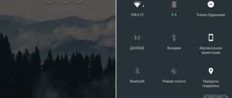
Quick Access Toolbar
- Swipe your finger across the screen from top to bottom and find the “Location” icon. To enable the function, just touch it.
- If you hold the icon, a screen with geolocation options will open (does not work on all versions of Android).
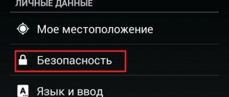
"System settings
- We are looking for the section “Biometrics and Security”, “Security and Privacy” or similar, and then “Location”, “Geolocation”, “Location Data”, etc.
- We go there and enable the function.
To set up geolocation and gain access to all its features, you need a Google account. How to create it and how to log into your account on an Android device is described in detail in separate articles.
Read more: Creating a Google account on an Android smartphone Logging in to Google on Android
Problems with geodata
Problems with geodata may arise for inexperienced users who have not yet understood the full functionality of the phone. The table shows common problems and ways to solve them.
Vyacheslav
For several years he worked in mobile phone stores of two large operators. I understand tariffs well and see all the pitfalls. I love gadgets, especially Android ones.
Ask a Question
Problems and solutions
The GPS sensor shows an error and does not work.
You should check your phone for viruses and also restart it. If this does not help, then you need to reflash the phone, since the problem is in the module, which can be solved by reflashing it.
Location services are not working.
It's worth checking that the settings are correct. To do this, you need to go to the settings and double-check all the points described above. Perhaps the problem is the lack of network.
The navigator doesn't work well.
You can check or reselect the service mode. For example, establish a comprehensive definition rather than some partial one.
4.4/5 — (27 votes)